

GIS Applications
GIS Applications
Connect maps, assets and operational data through purpose-built GIS applications for planning and field delivery.
GIS Applications combine location with business information so users can understand where assets, services, incidents, projects or customers are and how they relate. The service can deliver public maps, planning tools, operational dashboards, field-inspection apps and integrations with enterprise systems. Design begins with the decisions and workflows that location information must support.
GCC GIS environments may include authoritative basemaps, cadastral information, utility networks, BIM or engineering data, drone imagery and field updates. The application establishes data ownership, coordinate standards, edit permissions, quality rules and publishing controls to protect the integrity of location-based decisions. Albrandz Technology structures the engagement for organisations operating across Saudi Arabia, the UAE, Qatar, Oman, Bahrain and Kuwait, with clear scope, stakeholder responsibilities, review points, acceptance criteria and knowledge transfer.
What GIS Applications Includes
GIS Requirements and Data
Web Mapping Experience
Spatial Analysis
Field Mobility
Enterprise Integration
GCC Delivery Considerations for GIS Applications
Digital applications for GCC users may require Arabic and English interfaces, accessibility, mobile-first design, approved identity services, data classification, secure hosting and integration with existing platforms. Government delivery can include architecture review, security assessment, formal user acceptance and staged production approval. Private-sector delivery may prioritise speed to market, customer conversion and operational efficiency. Albrandz Technology uses release-based planning so that essential functions, dependencies and acceptance criteria remain visible throughout design, build, testing and transition.
Our GIS Applications Delivery Approach
The engagement is managed through clear stages and review gates. The exact activities are tailored to the confirmed scope, but a typical GIS Applications assignment follows the approach below:
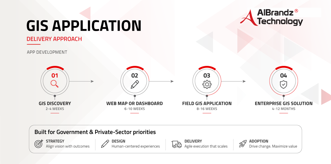
GIS discovery
Use cases, data inventory, standards, architecture, integrations and release roadmap. The stage includes stakeholder review, documented decisions and confirmation of the inputs required for the next phase.
Web map or dashboard
Data preparation, interface, analysis, security, testing and publishing. The stage includes stakeholder review, documented decisions and confirmation of the inputs required for the next phase.
Field GIS application
Mobile forms, offline use, synchronisation, workflows, testing and rollout. The stage includes stakeholder review, documented decisions and confirmation of the inputs required for the next phase.
Enterprise GIS solution
Multiple datasets, applications, integrations, governance and phased adoption. The stage includes stakeholder review, documented decisions and confirmation of the inputs required for the next phase.
Discuss your bi dashboards requirements with Albrandz Technology and request a tailored GCC delivery plan.
Benefits of GIS Applications
- Improves planning and operational understanding by presenting information in its geographic context.
- Supports faster field data collection, inspection, verification and work assignment.
- Connects asset, project and service records with authoritative locations and map layers.
- Reduces duplication by establishing shared spatial data, standards and update responsibilities.
- Supports phased releases, documented testing and maintainable handover for future enhancement.
- Connects digital user journeys with existing business rules, data and enterprise systems.
Who Needs GIS Applications?
- Municipalities and government authorities managing land, permits, services or public assets.
- Infrastructure, construction and real-estate organisations planning and monitoring projects.
- Utilities, airports, logistics and facilities teams managing distributed networks and assets.
- Environmental, transport and emergency organisations requiring spatial analysis or field coordination.
- Government entities digitising citizen, business, employee or field-service processes.
- Private organisations requiring secure custom applications that fit their operating model.
How Much Time Is Needed for GIS Applications?
Delivery time depends on scope, data and system readiness, stakeholder availability, procurement requirements, security reviews, integrations and approval cycles. Indicative delivery ranges are:
- GIS discovery (2-4 weeks): Delivery range subject to confirmed scope, inputs, approvals and resource availability.
- Web map or dashboard (6-10 weeks): Delivery range subject to confirmed scope, inputs, approvals and resource availability.
- Field GIS application (8-16 weeks): Delivery range subject to confirmed scope, inputs, approvals and resource availability.
- Enterprise GIS solution (4-12 months): Delivery range subject to confirmed scope, inputs, approvals and resource availability.
The final schedule is confirmed after discovery and scope validation. Government programmes may require additional time for tender procedures, governance approvals, security assessment, data classification, hosting decisions and formal acceptance.
GIS Applications
Click below to learn more about our services and solutions.